Mission 04-02
Injured Climber, Mt. Jefferson
by Bob Freund
![]()
| Member hours: 67
Participants: J. Linn, M. Crawford, J. Dagata, N. Vitagliano
| |
Click on photo for larger view Photo courtesy of Brent McGregor |
On Sunday, April 25th Brent McGregor (51) and Tom Herron (40) climbed Mt. Jefferson and descended via the west side of the mountain. They had summitted at 1730 and were descending unroped when shortly after 1900 Brent fell. In self-arresting his fall, Brent caught a crampon point and heard a pop and snap in his lower leg. He was unable to descend further and called for help on his cellphone. His call was received at the PSAP (911 center) in Stayton and they tapped out Gates Fire Department (before the call was turned over to the Linn County Sheriff). He was able to give his location from a GPS reading. Brent and Tom then prepared to spend the night on the mountain. The temperature remained above freezing throughout the night at their 7900 foot bivouac site with low winds and clear skies. |
|
CMRU was initially informed of the incident at 2023 after Camp Sherman Hasty Team had been contacted. Joy paged a Stand-by at 2039. But Linn County then informed CMRU that we were not needed.
Later, it was ascertained that the subjects were near the 8000 foot level of the mountain and we were activated.
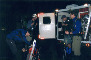
Three CMRU members arrived in base camp at 0230 and were teamed with three from Deschutes MRU who
arrived about 0315. Equipment was divided between CMRU, Deschutes, and ESAR Post 64 and they were all
on the trail by 0430.
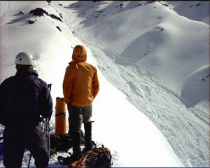
Shortly above where Milk Creek crossed the PCT, there was a 30 foot wall of avalanche debris which had come off the mountain. The team skirted this on the north side and continued to ascend. By the time the team reached 6000 feet, they had visual contact with the two subjects, but were on a ridge one large gully to the north of the two subjects. By 0930 the team was still about an hour away using snowshoes in the soft conditions. |
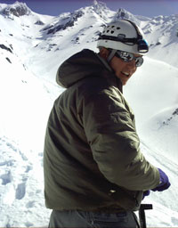 Matt on ridge Photo courtesy of Jim Dagata |
 Click on photo for larger view Photo courtesy of Brent McGregor |
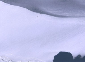
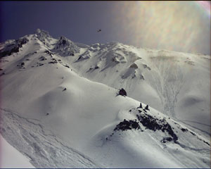
Click on photo for larger view which shows location of subjects. Photo courtesy of Jim Dagata |
|
There were avalanches on all aspects of the ridges and snow stability was very poor. Base then informed
the team that the National Guard’s 1042nd Air Ambulance Company was on Standby to assist and the reply was
to “spin them up.” The helicopter arrived at the mountain about 1010 and after a couple passes located the rescue team, but could not see the two subjects (who had been advised by the rescue team via cellphone to drag
themselves up to the top of their ridge). John (from Deschutes) suggested the rescue team form a line pointing toward the subjects. This was done and the helicopter was then able to spot the two.
First the flight medic was lowered to assess the two subjects. Then, Brent was hoisted into the helicopter with the flight medic on the jungle penetrator followed by Tom. The helicopter departed for Bend to deliver the climbers to St. Charles Medical Center. |
Click on photo for larger view Photo courtesy of Jim Dagata |
|
| |
|
The ground teams returned down the mountain as the snow conditions became more unstable. They were
met at the bottom of the snow by Posse members who were able to take some of the equipment. After getting
back to the trailhead, gear was sorted and repacked. Nate slept in his car at the trailhead before returning home
while Jim and Matt drove to Idanha to refuel before sleeping for an hour or so. They stopped in Mill City for
some food and were contacted by a member of Gates Fire Department who was curious how the mission ended.
Jim Dagata was team leader and reported that the mixed team of Deschutes and CMRU worked well together. Also, Laurie Adams, a member of Camp Sherman Hasty team, was at basecamp with the injured climber’s wife; and assisted in getting navigation points plotted and put into GPS units. |
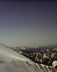
Photo courtesy of Jim Dagata |
|
Lesson Learned: Map datum for coordinates given to the field team for the subject’s location was not
specified. While these coordinates may have indeed come from the subject(s), they were plotted with a NAD 27
datum which led the rescue team onto the wrong ridge. When plotted using WGS-84, the subject’s position more
nearly agrees with their actual location. Most people don’t know about map datums and most GPS receivers
initially use WGS-84 – so, be cautious of coordinates derived by others. Ask about map datum and if your
question is met with silence or a blank stare – chances are good that the GPS in question is (still) on WGS-84.
| |